
What's New
v9.0
|
Charting
Perform advanced spatial analysis and generate reports
|

A group of tools are available on this toolbar which allow you to interact with your data.

Chart

|
Learn about Charts
https://support.mapsolutions.com.au/default.asp?W2112
|
|

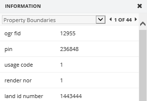
Information
|
This tool is used to retrieve information from the map layers in the map window. The data that the Information Tool can retrieve is limited to the spatial layers, whereas the Selection tools can retrieve data from multiple data sources.
- Click on the tool to activate it
- Click and hold the left mouse button and drag the cursor away from the point to create a circle
- An information window will appear offering you a drop down for all the different map layers you selected and their selected objects
- If you have selected multiple objects in a layer, you can scroll through them using the arrows on the right of the layer's list
|
|

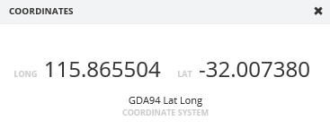
Coordinates
|
This tool is used to return the coordinates of a point on the map window
- Click on the tool to activate it
- Click on a location in the map window
- A coordinates window will appear with the coordinates of the Coordinate System chosen in the View Toolbar
|
|

Measure Distance
|
This tool is used to measure a distance on the map. You can activate Snapping which will force the cursor to snap to a layer whilst measuring which results in higher accuracy.
- Click on the tool to activate it
- A Result window will appear
- You can choose a snap layer if you wish or keep the default at none
- Select a location on the map and draw lines. the Distance will be written on the map and on your Results window
- Double click to complete the measurement. A total distance will be written on the map. These measurements will be removed when the Result window is closed.
|
|

Measure Area
|
This tool is used to measure an area on the map. You can activate Snapping which will force the cursor to snap to a layer whilst measuring which results in higher accuracy.
- Click on the tool to activate it
- A Result window will appear
- You can choose a snap layer if you wish or keep the default at none
- You can change the default unit from metres if you wish
- Select a location on the map and draw lines. the Distance will be written on the map and on your Results window
- Double click to complete the measurement
|
|